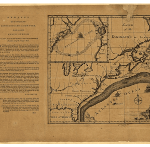
The Gulf Stream is a strong current from the ocean that facilitates certain parts of the US and Europe with a warm climate. The stream brings warm water from the Gulf of Mexico into the Atlantic Ocean extending up to the US and Canada. The warm water from the strong current influences the climate of the eastern part of coastal Florida in the US. The Gulf Stream influences the climate of those states with a warmer winter and cooler summer. The Gulf Steam extends up to Western Europe making the climate of England much warmer than other countries at the same latitude as Canada. It is a significant current system separating the warm and saline waters of the Sargasso Sea in the east from the colder and fresher continental slope water in the north and the west.
Image showing route of the Gulf Stream
The emergence of Gulf Stream
A big system of powerful winds and circular currents known as oceanic gyre leads to the emergence of the Gulf Stream. The Gulf Stream is one of the five oceanic gyres on the Earth, it is the component of the North Atlantic Subtropical Gyre. The oceanic waves are always moving the waters from one place to another through currents. The Gulf Stream moves the warm water from the Gulf of Mexico to the Norwegian Sea up to the north. Here, the warm water pushes off the colder water while the latter being denser sinks. The colder and denser water moves towards the South flowing across the ocean bottom till Antarctica.
The Gulf Stream was discovered by the Spanish explorer, Ponce de Leon as he evidenced the presence of a strong current in 1513. While exploring the sea, Ponce realized that the Gulf Stream can help the ship sail easily from Mexico to Spain. Benjamin Franklin and James Poupard in 1786 mapped first time the path of the Gulf Stream. Since the first mapping in the late 18th century, technological progress has been immense. Nowadays, highly advanced satellite imagery is used to study the route of the Gulf Stream. The Geostationary Operational Environmental Satellite-R (GOES-R) is used to track the movement of the Gulf Stream.
Image of the first map of the Gulf Stream
GOES-R helps in sourcing relevant information on the sea surface temperature in the Atlantic Ocean influencing the climate of the region. The satellite imagery on the sea surface temperature delivers accurate information on the route followed by the Gulf Stream. The information on the sea surface temperature owing to the Gulf Stream benefits the scientists to predict the climate of the region. The images of the Gulf Stream helps to understand the changes happening across the ocean like the movement of the fishes, unexpected changes in the weather and climate of the coastal areas, alongside decolorizing of corals.
Satellite image of the Gulf Stream
Current scenario of the Gulf Stream
Climate scientists have observed a deteriorating phenomenon across the route of the Gulf Stream. There are early signs of collapse, courtesy the global warming. The Gulf Stream is estimated at its slowest verge within the last 1,600 years of its trajectory. If the Gulf Stream ceases to exist, it will be a catastrophe globally. The climatic conditions in countries like India will be affected such as the reduced amount of rainfall. It means a lower amount of food productivity, enhances the tendency of storms, and further endangers the Antarctic ice sheets and the Amazon rainforest.
The Gulf Stream is crucial in delivering a warm climate across Europe like England experiences a warmer winter and cooler summer. Both England and Canada are equidistant from the equator. But England enjoys a warmer climate than Canada due to the Gulf Stream. So if the Gulf Stream is disrupted, Europe will experience a much colder climate. It will affect the lives and livelihood of the Europeans as the entire climatic condition goes a sea change. The environmentalists are appealing to the competent authorities to preserve the Gulf Stream. With time, the Gulf Steam is losing its chance to survive and now, it is the perfect time to act.
08.01.22


